
The VFR moving map for flying in Portugal
Airspace, aerodromes, VFR points, weather and NOTAM for Portuguese airspace, with your GPS position, on iPhone, iPad, Android, laptop and desktop. Plan the route, work out the navlog with the forecast wind and fly even without a signal.
Free and ad-free. Support Rumo with a T-shirt
A situational awareness aid. Rumo VFR is not certified for navigation and does not replace the aeronautical chart, the altimeter or the official NAV Portugal briefing.
The app is in Portuguese. The map, the aviation data and abbreviations such as CTR, METAR and NOTAM are international, but the menus and buttons are in Portuguese for now. On this page, menu names are given in Portuguese with a translation.
More European countries soon. For now Rumo VFR covers Portuguese airspace. We are preparing the expansion to other European countries. Stay tuned.
Everything a VFR flight needs, on one screen
Official data from the eAIP and the eVFR Manual, completed with openAIP and CAVOK.pt, drawn to be read in a cockpit.
Aeronautical map
CTR, TMA, restricted and danger areas, active SUPs, aerodromes, microlight fields, VFR points, routes and corridors, navaids and obstacles. Clean, topographic, road or satellite base map.
Alerts
Airspace ahead at your altitude, with configurable warning time, obstacles on your path and a warning for the end of VFR daylight.
Route and navigation
Direct-to any point, multi-point routes that sequence automatically, track, distance, ETE and cross-track error always in view.
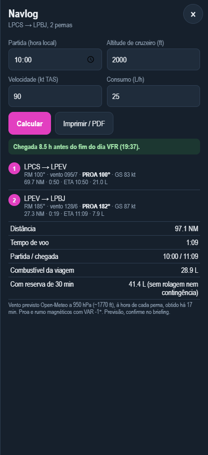
Navlog with wind
Wind-corrected heading, GS, times, ETA and fuel per leg, using the forecast wind at the time of each leg. Ready to print.
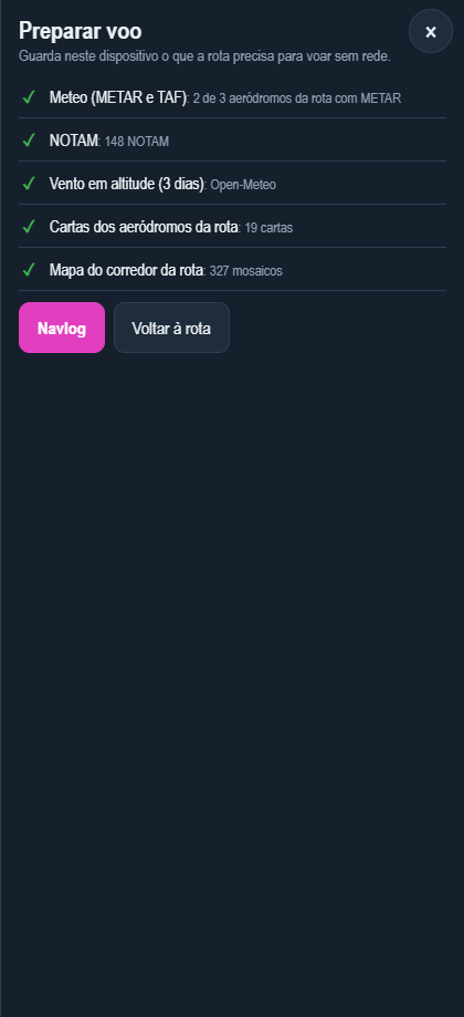
Prepare the flight for offline
One tap (Preparar voo) saves the weather, NOTAM, wind, aerodrome VAC charts and the map along the route corridor. Then fly without a signal.
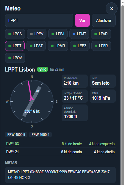
Weather and NOTAM
METAR and TAF with flight category, wind relative to the runways, density altitude and the Portuguese NOTAM PIB on the map and by aerodrome.
VFR daylight
End of civil twilight always visible, sunrise and sunset by aerodrome, and a warning if the planned arrival is after the end of daylight.
ADS-B traffic
Optional layer with traffic from the adsb.lol network and its altitude relative to yours. Awareness only: it is not a collision-avoidance system.
optional, needs a data connectionSimulator
With rumo-bridge on your PC, the app follows your aircraft in Microsoft Flight Simulator 2020 or 2024. Good for rehearsing the route before flying it. Download
Plan, check, fly
The navlog, the weather and the offline preparation are one tap away from the route.
Install on any device
It is a web app: it works on iPhone, iPad, Android, laptops and desktops, needs no app store and updates itself.
iPhone and iPad
- Open in Safarirumovfr.com
- Share, Add to Home ScreenYou get an icon like your other apps, and it opens full screen.
- Allow locationOpen it from the icon and choose "While Using the App", with Precise Location on.
- Calibrate the altitude on the groundAt an aerodrome, in Config., Calibrar no solo (calibrate on the ground). GPS altitude is geometric, not the altimeter’s.
Android
Open rumovfr.com in Chrome and use the menu, Install app (or Add to Home screen). Allow location when the app asks.
Laptop and desktop
Works in Chrome, Edge, Safari or Firefox, on Windows, macOS or Linux. In Chrome and Edge you can install it as an app from the icon in the address bar. Great for planning the route and navlog on a big screen, or for flying in the simulator.
No GPS
Wi-Fi-only iPads and most laptops have no GPS. To fly, use an external Bluetooth receiver (Bad Elf, Garmin GLO) or your phone.
Screen on
While the app is open, the screen stays on (you can turn this off in Config.). Take a power bank on long flights.
Before every flight
With a connection, at home or at the flying club.
- Build the routeTap aerodromes and VFR points and choose Adicionar à rota (add to route), or search in Rota (route).
- Preparar voo (prepare flight, offline)Saves weather, NOTAM, wind, VAC charts and the corridor map. The route shows when it was prepared.
- NavlogDeparture time, altitude, speed and fuel flow. Check you arrive before the end of VFR daylight, and print it if you like.
- Official briefingCheck the weather and NOTAM in the NAV Portugal briefing. The app’s data is an aid, not the official source.
- Iniciar navegação (start navigation)On the ground, with GPS. Navigation sequences automatically from point to point.
Always up-to-date data
The server rebuilds the data every Thursday, the day AIRAC cycles start, and only publishes it if the build is complete.
Sources: eVFR Manual and eAIP © NAV Portugal; openAIP (CC BY-NC); CAVOK.pt; NOTAM from the public PIB at notaminfo.com (EAD Eurocontrol data); METAR and TAF from aviationweather.gov; winds aloft Open-Meteo; traffic adsb.lol; maps © OpenStreetMap, OpenTopoMap, Natural Earth and Esri.
Support Rumo
Rumo VFR is free and will stay that way, with no ads and no subscriptions.
If the app is useful to you, you can help pay for the server, the data and the development hours with a T-shirt, a cap or a donation. Every purchase keeps Rumo flying and takes the logo to your flying club.
- T-shirts and sweatshirts
- Caps
- Mugs and notepads
- Stickers for your flight bag and iPad
Train in the simulator
rumo-bridge connects Microsoft Flight Simulator 2020 or 2024 to Rumo VFR on your tablet, phone or another computer, over your home Wi-Fi.
Plan the route, fly it in the simulator and watch the aircraft move on the map, with the navlog, airspace alerts and real weather. It is the best way to get to know the app before taking it into the aircraft.
Windows, free, 8 KB
Requires Node.js 18 or later. The PC and the tablet or phone must be on the same network, and the PC online: the app and data always come from rumovfr.com, so there is nothing to download again when the data changes. It also sends your position as XGPS to Android apps and other EFBs.
- Install Node.jsFrom nodejs.org, the LTS version.
- Extract rumo-bridgeTo a permanent folder, for example Documents.
- Open start-bridge.batThe first time, it installs what it needs. Allow Node.js on private networks when the firewall asks.
- Open the address on the tablet or phoneThe window shows an address such as http://192.168.1.20:8080. Open it in the browser (Safari on iPhone and iPad), not from the app icon.
- Choose the simulatorIn Config., Simulador MSFS, 2020 or 2024. Start a flight and the aircraft appears on the map.
Buying or selling an aircraft?
TaxiwayMarket is the aircraft marketplace made by the Rumo VFR team.
Listings for aeroplanes, helicopters, gliders and microlights with full specs, hours, avionics and photos, direct contact with the seller and no commission. Includes Full stop, free, for parts, avionics, hangars and services.
Contact
A question, a suggestion or an error in the data? Write to us.
If you found a wrong airspace, VFR point or frequency, tell us which one and where. Flying clubs and schools that want to use Rumo VFR in their lessons are also welcome. We reply by email, in Portuguese or English, as soon as we can.